Introduction
Flood retention basins collect surface runoff within a catchment, with potential retention areas identified using digital terrain models (DTM) and topographic maps. [1] Their effectiveness relies on variations in flow time intervals and a well-coordinated management strategy to optimize retention volume and peak reduction. [2] Flood retarding basins, located upstream of protected areas, store and release water gradually to mitigate flooding. Integrated with broader flood protection measures, they enhance resilience and planning. The purpose of this assignment is to develop an ontology for flood retention basins, providing a structured framework for knowledge sharing and interoperability. It enhances decision-making, supports flood mitigation, and demonstrates adaptability through parametrization and instantiation.
The scope of this ontology is to systematically represent flood retention basins by defining their key components, materials, operations, and maintenance requirements. It categorizes essential elements such as catchment areas, physical structures, operational forms, and maintenance tasks while incorporating real-world examples for practical application. By establishing properties, relationships, and constraints, the ontology enhances knowledge sharing, interoperability, and decision-making in flood management and engineering.
This ontology is designed for use by engineers, environmental scientists, urban planners, policymakers, and researchers working on flood management and infrastructure development. Its purpose is to offer a structured framework for modeling and analyzing flood retention basins, supporting knowledge sharing, informed decision-making, and system interoperability. The ontology can be applied in the design, optimization, and maintenance of flood retention basins, evaluating flood mitigation strategies, and integrating flood control measures into wider environmental and urban planning efforts.
Class Hierarchy
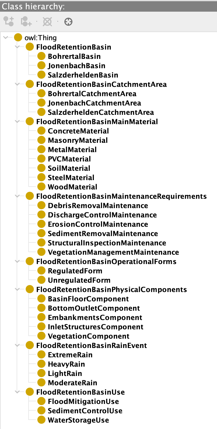
Based on the work of Noy and McGuinness, an ontology includes classes that represent concepts within a domain, each defined by specific properties and attributes. [3] These classes can also have subclasses, which are more detailed instances of the broader class.Here are the main classes and their subclasses to provide a clear overview of how a flood retention basin operates and its key components.
Ontograph
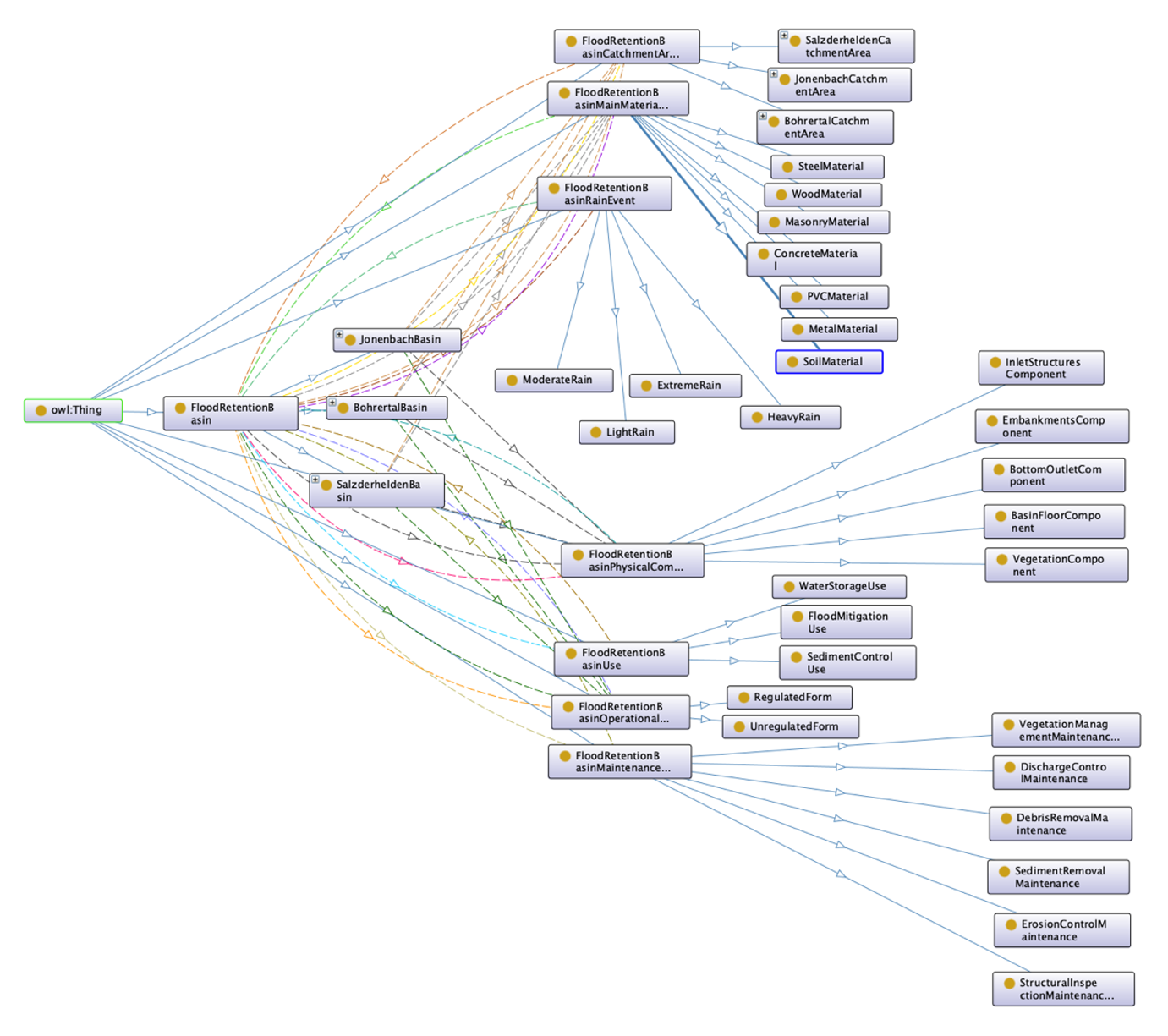
To view the ontology in protégé, the OntoGraf plug-in is used. After creating the classes, hierarchy, and defining their relationships with axiomatic examples, we developed an ontology visualization for the flood retention basin, as shown in the figure below.
Engineering Examples
Here are three engineering examples with their specific scenario and use case:
1. Integrated Flood Risk Management System
Scenario: A regional flood control authority manages a network of flood retention basins in an area prone to heavy rainfall and flooding. Timely decision-making is crucial during extreme weather events to protect infrastructure and communities.
Use Case: The ontology-based system helps engineers and decision-makers manage flood retention basins by integrating real-time weather data and hydrological models. It predicts flood risks, assesses basin status, and suggests mitigation actions such as adjusting storage or releasing water. This automation supports faster, more informed decisions during critical flood events.
2. Maintenance and Monitoring Framework
Scenario: A flood retention basin authority oversees multiple basins and needs an efficient way to monitor and schedule maintenance, while managing repair costs.
Use Case: The ontology-driven system models maintenance requirements (e.g., sediment removal, erosion control) and links them to relevant components. It automates scheduling, ensures consistency, and reduces the risk of overlooked issues.
3. Flood Retention Basin Design Optimization
Scenario: Engineers design new flood retention basins for a catchment area and need to incorporate past data and best practices for optimal designs.
Use Case: The ontology-driven system creates a library of design concepts, linking parameters like catchment area, crest width, volume, and rainfall events. Engineers can make intelligent queries to adjust designs based on regional rainfall patterns, streamlining the design process and encouraging collaboration. The system is user-friendly for new designers.
References
[1] Univ.-Prof. Dr. Hinkelmann, Engineering Hydrology – Hydrological Processes, Lecture
[2] Retention basins, Sieker – The stormwater experts https://www.sieker.de/en/fachinformationen/measures-for-rural- areas/article/rueckhalteraeume-231.html
[3] Ontology Development 101: A Guide to Creating Your First Ontology, Natalya F. Noy and Deborah L. McGuinness, Stanford University, Stanford, CA, 94305

